Floodplains
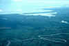 Meandering
rivers indicate depositional environments were sediment transported in approximately
equals sediment transported out. Floodplains of such rivers usually include at least
all of the land between meandering channels. Photo taken from window of commercial
aircraft, north coast of Honduras, July, 1995.
Meandering
rivers indicate depositional environments were sediment transported in approximately
equals sediment transported out. Floodplains of such rivers usually include at least
all of the land between meandering channels. Photo taken from window of commercial
aircraft, north coast of Honduras, July, 1995.
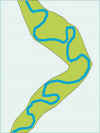 In this cartoon,
the rich green is likely to become flooded as the river (blue) rises out of its banks.
The flat land nearby is also floodplain, although it is covered with water less
frequently.
In this cartoon,
the rich green is likely to become flooded as the river (blue) rises out of its banks.
The flat land nearby is also floodplain, although it is covered with water less
frequently.
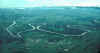 More north
coast meanders, 1995. A similar perspective just after Mitch would show almost
the entire foreground under water. Sediment of the floodplain is also mobile.
Erosion is lateral, particularly along bends in the channel. The outside part
of the bend erodes, with deposition on the inside of the bend. Meanders get
increasingly contorted until outsides of two bends meet - and is about to occur just left
of center of this image. The abandoned channel forms an oxbow lake, which gradually
fills with sediment.
More north
coast meanders, 1995. A similar perspective just after Mitch would show almost
the entire foreground under water. Sediment of the floodplain is also mobile.
Erosion is lateral, particularly along bends in the channel. The outside part
of the bend erodes, with deposition on the inside of the bend. Meanders get
increasingly contorted until outsides of two bends meet - and is about to occur just left
of center of this image. The abandoned channel forms an oxbow lake, which gradually
fills with sediment.
Floodplains in mountainous areas (like Tegucigalpa) can also be identified
from their shapes and other clues, if human activities have not obliterated too much of
the geological evidence. The floodplain hazard is rated in terms of the probability
that a flood will cover a particular part of the floodplain in any given year. If
the probability is 5% (1 in 20)
that, during any given year, water will cover where you are standing, you are on the
20-year floodplain. This does not mean floods are 20 years apart. The
floodplain has no memory.
Return to "Tegicugalpa before Mitch"

 Meandering
rivers indicate depositional environments were sediment transported in approximately
equals sediment transported out. Floodplains of such rivers usually include at least
all of the land between meandering channels. Photo taken from window of commercial
aircraft, north coast of Honduras, July, 1995.
Meandering
rivers indicate depositional environments were sediment transported in approximately
equals sediment transported out. Floodplains of such rivers usually include at least
all of the land between meandering channels. Photo taken from window of commercial
aircraft, north coast of Honduras, July, 1995.
